Navigate Kongma La, Cho La, and Renjo La with Confidence
The Three Passes Trek is one of the most exciting treks in the Everest region of Nepal. It takes you through three high mountain passes: Kongma La, Cho La, and Renjo La. These are some of the highest and most beautiful places in the Himalayas. To do this trek safely and with confidence, you need to understand the trail and plan ahead.
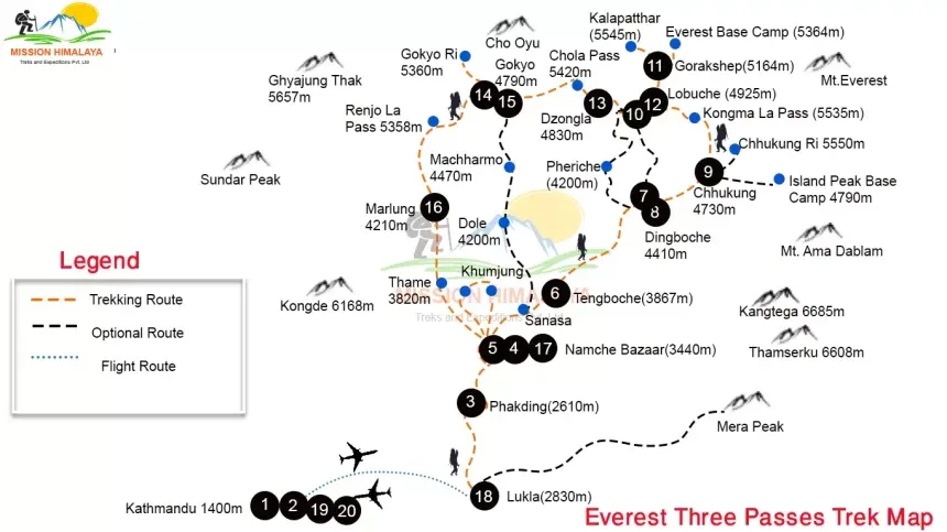
This is where a good Three Passes Trek Map helps a lot. It shows the full route, with clear paths leading to each pass. It also shows nearby villages, rivers, and mountains. Having a map helps you know where you are and what’s coming next.
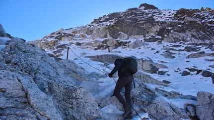
The first pass, Kongma La, is the highest of the three at around 5,535 meters. It lies between Chukhung and Lobuche. The trail is steep and rocky, and it can be snowy, even in warmer months. Start early in the morning and take slow steps. The view from the top is amazing, with giant peaks all around. Your Three Passes Trek Map will help you find the safest route and spot where to rest.
The second pass is Cho La, which connects Dzongla and Thangnak. It’s about 5,420 meters high. This pass can be icy and slippery. You may have to walk across a glacier. It’s a good idea to check your map the night before. The map shows where the trail gets tough and where you need to be extra careful. Walking poles and warm clothes help here.
The last pass is Renjo La, at about 5,360 meters. It links Gokyo and Lungden. This trail is a bit easier than the first two, but still long and tiring. From the top, you can see Everest and many other mountains. The Three Passes Trek Map shows how to reach Renjo La from Gokyo and how long it may take.
Using a good map, walking slowly, and listening to your body can help you complete the Three Passes Trek safely. Each pass is hard but also full of beauty. With a clear plan and your Three Passes Trek Map, you can enjoy the journey with more confidence and less stress.
Step-by-Step Route Overview with Villages, Passes, and Peaks
The Three Passes Trek is a long walk in the mountains of Nepal. It takes you through three high passes and many small villages. You also get to see tall mountain peaks like Mount Everest. It can feel confusing at first, but when you look at a Three Passes Trek Map, the route starts to make sense.
The trek usually starts in a town called Lukla. This is where most people fly in to begin the journey. From Lukla, you walk to Namche Bazaar, a busy village where trekkers rest and get used to the high altitude. Your Three Passes Trek Map will show how far Namche is and how high it sits.
After Namche, the trail splits. Some people go to the Everest Base Camp first. Others go toward the first pass, Kongma La. Before crossing this pass, you may stop in a village called Chukhung. Kongma La is a tough climb but offers views of glaciers and snow-covered peaks.
After that, the trail leads to Lobuche, a small village where many trekkers rest. From here, you can go to Everest Base Camp and then return to cross the second pass, Cho La. Before the pass, you sleep in Dzongla, and after the pass, you reach Thangnak, a peaceful village near a glacier.
Next, the route heads to Gokyo, a beautiful place with blue lakes and mountain views. From Gokyo, you cross the last pass, Renjo La, and see views of Everest and other big peaks. This part of the trek is quiet and not as crowded.
After Renjo La, you walk down to Lungden and later return to Namche Bazaar. The trek ends back in Lukla, where your journey began.
Throughout the trek, your Three Passes Trek Map will guide you. It shows the names of villages, where the passes are, and where the peaks stand. It helps you plan each day and know what to expect.
With a good Three Passes Trek Map, you can follow the route step by step. You’ll know where to eat, where to sleep, and where to stop and look around. The map makes the journey easier to understand and enjoy.
Visual Map Guide for Planning Your Ultimate Everest Adventure
Planning a big trek like the Three Passes Trek in Nepal can feel like a lot at first. There are many trails, villages, and high mountain passes. That’s why a good Three Passes Trek Map is very helpful. It shows the full path step by step so you can understand where you are going each day.
A visual map is not just lines and names. It shows mountains, rivers, forests, and small villages. You can see where the trail goes up, where it goes down, and where it gets harder. This helps you get ready, both in your mind and with your gear.
The trek starts in Lukla, where you begin walking. The map shows how the trail leads to Namche Bazaar, a village where most trekkers rest. From there, the map shows two paths—one toward Everest Base Camp, and one toward the first high pass, Kongma La. When you look at the map, it becomes easier to decide which way to go first.
A Three Passes Trek Map also shows where you’ll find teahouses to sleep in and places to eat. It helps you know how many hours you might walk each day. This way, you don’t push yourself too hard. If you see a steep climb on the map, you can get ready by waking up early and carrying snacks.
The map also marks special places like Cho La Pass, Renjo La Pass, and lakes in Gokyo. These are beautiful spots but can be tough to reach. A map helps you plan how to get there safely. It also shows how far these places are from each other, so you can plan your stops.
Using a Three Passes Trek Map, you can make a smart plan for your adventure. You’ll know where you’ll be sleeping, where the hard parts are, and where to take breaks. It makes the trip feel less scary and more fun.
With your map in hand, you can plan your Everest journey with confidence. The pictures and symbols help you see the full path clearly. A Three Passes Trek Map is more than just a tool. It’s your guide to an amazing trip in the Himalayas.
Understand the Terrain: Elevation, Distances, and Trail Splits
The Three Passes Trek is not just a long walk. It is a journey through high mountains, deep valleys, and rocky paths. To stay safe and enjoy the trip, it helps to understand the terrain. This means knowing how high you’ll go, how far you’ll walk, and where the trail splits into different directions. A Three Passes Trek Map is the best way to learn all this.
First, let’s talk about elevation. This is how high you are above sea level. The trek starts in Lukla at around 2,800 meters. As you move on, the trail goes much higher. The highest point is Kongma La Pass, which is over 5,500 meters. That’s very high, and some people feel tired or get headaches. If you look at your Three Passes Trek Map, you’ll see the heights of each place. This helps you know when to rest and when to go slow.
Next is distance. Some days, you may walk only 4 to 5 hours. Other days, the walk can be longer and harder. For example, crossing a pass like Cho La can take 7 to 8 hours, especially if there’s snow or ice. The map shows the distance between villages like Namche, Chukhung, and Gokyo. This helps you plan how much food and water to carry for each day.
Now let’s talk about trail splits. On this trek, there are many paths that go in different directions. Some lead to Everest Base Camp, and others take you to the high passes. At places like Dingboche or Gokyo, the trail can split. A Three Passes Trek Map shows where these splits are and where each one goes. This helps you avoid getting lost and makes it easier to follow your own plan.
When you understand the terrain, the trek becomes less confusing. You’ll know what’s ahead and be ready for it. With a good Three Passes Trek Map, you can see where the trail climbs, where it turns, and where it gets steep. This makes a big difference when walking in the mountains.
A map is not just paper with lines. It’s a guide that helps you stay on track, stay safe, and enjoy the beauty of the Himalayas.
Your Trekking Companion: GPS Insights and Essential Stopovers
When you go on the Three Passes Trek, it helps to have something to guide you. A GPS and a Three Passes Trek Map can be your best friends on the trail. They help you know where you are and where you need to go. They also help you find good places to stop and rest along the way.
GPS stands for Global Positioning System. You can use it on your phone or a small handheld device. It shows your location on the map in real-time. So even if the trail looks confusing, the GPS will help you stay on the right path. Some GPS apps also work without the internet, which is great because the mountains don’t always have a signal.
Your Three Passes Trek Map works with the GPS to give you more detail. While the GPS shows your dot on the trail, the map shows names of villages, mountains, rivers, and passes. You can zoom in and out to see where the next big climb is or where the next teahouse might be.
Along the trek, there are some important stopovers where you can eat, sleep, and rest. One big stop is Namche Bazaar. It’s a busy village with shops, bakeries, and even a small museum. Many trekkers spend two nights there to get used to the high altitude.
Another helpful stop is Gokyo, a peaceful place with blue lakes and mountain views. Many people rest there before crossing Renjo La Pass. The Three Passes Trek Map will show how far Gokyo is from the last village and where you can stay for the night.
Lobuche, Dzongla, and Chukhung are other key stopovers. These places are small, but they have teahouses where you can get warm food and a bed. You’ll see them marked on your map, and your GPS will show you how close you are.
Using a Three Passes Trek Map with GPS gives you peace of mind. Even if the weather changes or the trail is covered in snow, you can find your way. You’ll know when to stop, when to keep going, and when to rest. With these tools, the trek feels easier, safer, and more enjoyable.
Conclusion
The Three Passes Trek is an amazing adventure through high mountains, beautiful villages, and snowy passes. Having a good Three Passes Trek Map helps you understand the route, plan your days, and stay safe. It shows important details like elevations, distances, and trail splits, making it easier to navigate. Using GPS with your map guides you through tricky parts and helps you find places to rest. With these tools, you can walk with more confidence and enjoy every moment of your Everest journey. A clear plan and the right map make all the difference on this unforgettable trek
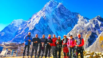
I have had the privilege of leading countless trekkers through some of the world’s most iconic routes, including the Everest Base Camp Trek and Annapurna Base Camp Trek. Every trek is not just a physical journey; it’s an opportunity to connect with nature, immerse ourselves in rich cultures, and create lasting memories.
I believe that trekking is about more than just reaching a destination; it’s about the stories we share along the way. My fluency in Spanish, English, Hindi, and even some Japanese and Korean allows me to connect with trekkers from all walks of life, ensuring that every journey is tailored to your unique desires and needs.